University of
Texas at Austin
Center for Research in Water Resources
Project: System of GIS-Based Hydrologic and Hydraulic Applications for
Highway Engineering
Sponsored by: Texas Department of Transportation (TxDOT)
Principal Investigator: David R. Maidment, Ph.D.
Project Manager: Francisco Olivera, Ph.D.
Graduate Research Assistant: Juling Bao
POTENTIAL EXTREME PEAK DISCHARGES IN TEXAS
by Francisco Olivera and Juling Bao
December 19, 1996
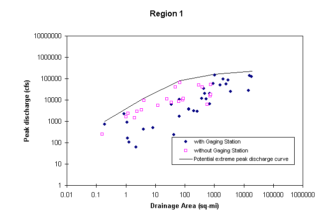
Potential extreme peak discharge is an estimate of the highest peak discharge expected to occur at a certain location. Following the methodology presented by Asquith and Slade (1995), a grid of potential extreme peak discharges in Texas has been prepared. According to their methodology, potential peak discharges are calculated exclusively as a function of drainage area and hydrologic region. The grid has a resolution of 500 m by 500 m, and stores the potential peak discharge at all locations of Texas.
To develop a grid of potential extreme peak discharges requires three processes:
A brief discussion of each part of the methodology is included below.
Documented extreme peak discharges for a total of 619 sites with streamflow-gauging stations and 213 sites without streamflow-gauging stations in natural basins, were collected. For each site, the following information was provided: USGS station number and name or stream name and approximate location, hydrologic region number, latitude, longitude, drainage area, documented extreme peak discharge and date of occurrence.
It was found that documented extreme peak discharges better correlate with contributing drainage area than with any other watershed characteristic, such as channel length or slope, and therefore the other characteristics were not used for estimating potential peak discharges. Asquith and Slade, though, do not mention in their report other physical characteristics of the watershed, such as land-use, soil type, or geology, that might affect how storm runoff is routed through the terrain.
The methodology for estimating potential extreme peak discharges consists of plotting in a chart documented peak discharges vs. drainage area for all the stations of a hydrologic region, and drawing an envelope curve above all the observed values. Stations as far as 40 Km from the region border were also considered in the plot. In developing this curve, it was assumed that potential peak discharges are greater than the 100-year peak discharges, already available from other USGS studies. One envelope curve is to be developed for each hydrologic region and a set of mathematical equations is defined to describe this curve. These equations are available at Potential Extreme Peak Discharge Equations.
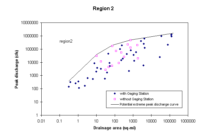
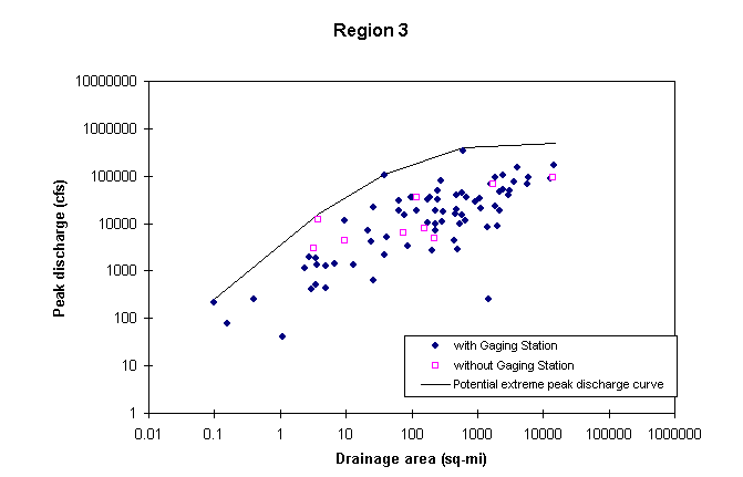
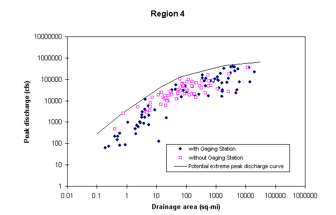
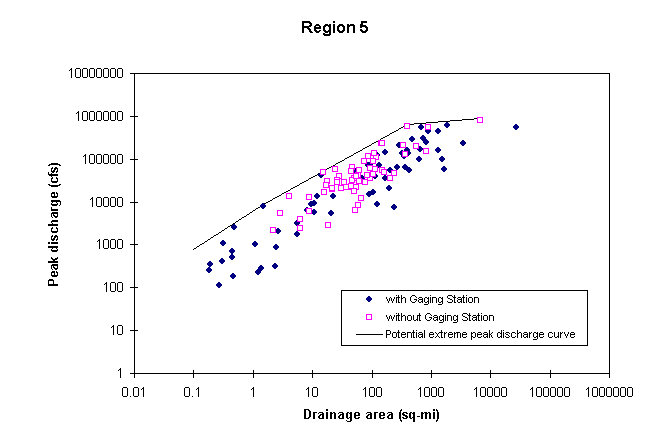
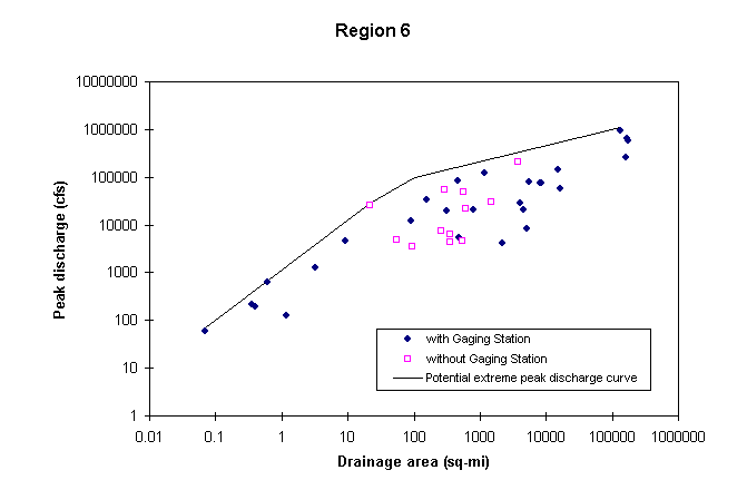
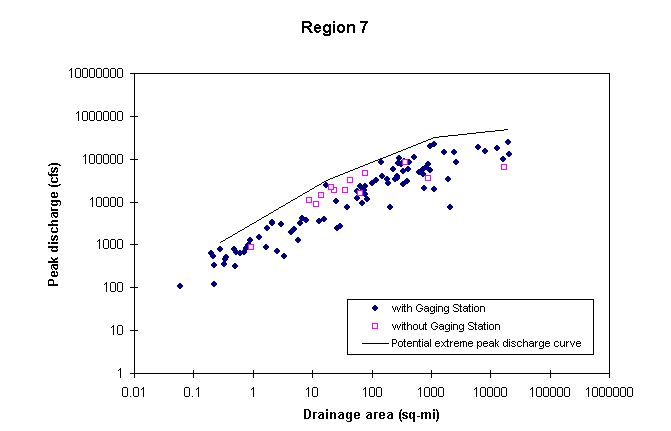
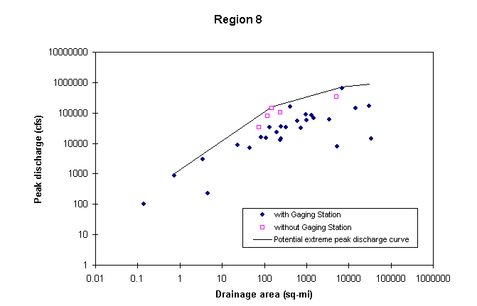
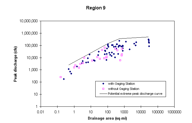
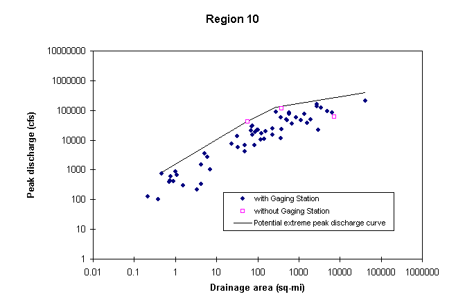
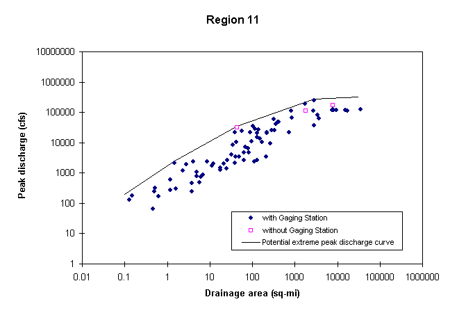
The equations determined with this methodology apply to natural basins for which the peak discharges are not effected by regulation, reservoirs, diversions, urbanization, or other human-related activities, and therefore should not be applied close downstream of reservoirs and cities.
It has been observed that, as an average, potential peak discharges are 74% of the probable maximum flood peak discharge. This discharge calculated based on probable maximum precipitation (PMP).
The reader is referred to Asquith and Slade (1995) for detailed discussion of the methodology used to establish the relation between potential peak discharge, drainage area, and flood region.
Calculating the drainage area of all locations of Texas requires to consider the areas out of the state that drain towards it, i.e., the Southern part of Oklahoma, the Western part of Louisiana, the Eastern part of New Mexico and the Northern part of Mexico. In other words, all the drainage area of the Gulf of Mexico from the Sabine River to the Rio Grande. The topography of the study area is described by the 15’ DEM, available for the United States, and by the North America 30’ DEM. The digitized stream network is taken from EPA’s river reach file RF1.
After burning-in the digitized streams on the DEM, the standard Arc/Info-Grid hydrologic functions were applied. Burning-in the streams consists of adding a constant number to the DEM value in all cells but those that coincide with the observed streams. This process does not force the water to flow towards the streams, but forces it to remain in the streams once it gets there. This burning-in process has proved to be an efficient way to alter the DEM, in such a way that produces delineated streams that match the digitized ones. Next, the Arc/Info-Grid functions FILL, FLOWDIRECTION and FLOWACCUMULATION were run on the modified DEM. Finally, the flow accumulation grid was multiplied by the grid cell area (0.0965 sq-mi) to give the drainage area grid in sq-mi.
This methodology to calculate the drainage area does better with large watersheds in which the absolute errors tend to offset each other, and the relative errors tend to be small. As a rule of thumb, a minimum of 100 cells of drainage area is recommended. This implies that drainage areas of 10 sq-mi or less would be considered inaccurate.
The hydrologic region grid was produced by rasterizing the hydrologic-region polygon coverage obtained from William Asquith of the USGS.
The grid of potential extreme peak discharges was created with a set of condition statements that, for each grid cell, evaluated the hydrologic region number and the drainage area, and then applied the corresponding equation to calculate the potential extreme peak discharge.
The grid of potential extreme peak discharges is a powerful tool for estimating design flows for highway hydraulic-structures.
This grid tends, though, to overestimate flows since some watershed characteristics, such as land use, soil type, or geology, have been ignored and worst-case values have been predicted. Considering these variables is a matter of further research and not just a correction of the actual methodology.
The effect of reservoirs and cities on the downstream water bodies has not been considered yet. However, it does not seem to imply a drastic change of methodology, since only the areas close downstream of dams and urban centers would have to be corrected. However, it is not clear yet, how this correction would be applied.
Asquith, W., and R. Slade (1995), Documented and Potential Extreme Peak Discharges and Relation Between Potential Extreme Peak Discharges and Probable Maximum Flood Peak Discharges in Texas, USGS Water-Resources Investigations Report 95-4249. Prepared in cooperation with the Texas Department of Transportation (TxDOT).