CE 394 K - GIS in Water Resources
CE 394 K.3
Semester Project Outline - Status Report
Terrain Stability Hazard Mapping Using GIS
Department of Civil Engineering University of Texas at Austin
Fall 1999
Project Status
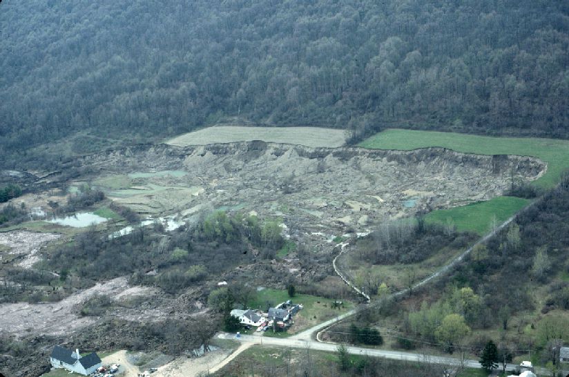
At the discretion of Dr. Maidment, and due to limitations in available data, the scope of my semester project has changed significantly. The original project was to rely heavily on SNOTEL data, which was to provide historical snow-water equivalent, snow density, and snow depth data. Upon investigation, it was determined that Colorado has only 80 SNOTEL sites, with only a handful (16) that measured the required parameters several times each day. It was also determined that this data was not available electronically at this time, so significant effort would have been required to create a point coverage in GIS.The purpose of my project as it now stands is to investigate and map areas of suspect slope stability throughout the State of Colorado. I have spoken with Dr. David Tarboton with Utah State University to inquire about the applicability of using the Stability Index Approach to Terrain Stability Hazards Mapping (SINMAP) model for assessing terrain stability conditions in the GIS framework.
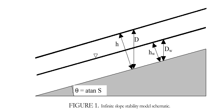
SINMAP is a grid-based ArcView extension developed with the support of Forest Renewal British Columbia, in collaboration with Canadian Forest Products Ltd., Vancouver, B.C. It relies heavily on the coupling of steady state topographic hydrologic models with the infinite plane slope stability model. SINMAP has its theoretical basis in the infinite plane slope stability model with wetness (pore pressures) obtained from a topographically based steady state model of hydrology.
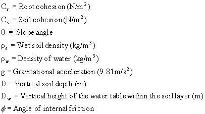
The application of the infinite slope stability model will yield a factor of safety with respect to terrain instability, based on parameters such as:
The infinite slope stability model factor of safety (ratio of stabilizing to destabilizing forces) is given by (simplified for wet and dry density the same, from Hammond et al., 1992):
![]()
The minimum factor of safety, then, can be considered the Stability Index. The following table presents the Stability Class Definitions:
Condition |
Class |
Predicted State |
Parameter Range |
Possible Influence of Factor Not Modeled |
SI > 1.5 |
1 |
Stable slope zone |
Range cannot model instability | Significant destabilizing factors required for instability |
1.5 > SI > 1.25 |
2 |
Moderately stable slope zone | Range cannot model instability | Moderate destabilizing factors required for instability |
1.25 > SI > 1.0 |
3 |
Quasi-stable slope zone | Range cannot model instability | Minor destabilizing factors could lead to instability |
1.0 > SI > 0.5 |
4 |
Lower threshold slope zone | Pessimistic half of range required for instability | Destabilizing factors are not required for instability |
0.5 > SI > 0.0 |
5 |
Upper threshold slope zone | Optimistic half of range required for instability | Stabilizing factors may be responsible for stability |
0.0 > SI |
6 |
Defended slope zone | Range cannot model instability | Stabilizing factors are required for stability |
As for the methods employed to determine slope and specific catchment area, the routines found in SINMAP are similar to those developed by CRWR at the University of Texas at Austin. However, SINMAP does not use the 8-direction pour point model currently used by the CRWR PrePro extension. Rather, SINMAP uses the D-infinity model (multiple flow direction model) developed by Tarboton (1997). This allows the flows from any cell in the grid to be split proportionally to the neighboring cells, as defined by the lattice points in the DEM. Progress to Date Once it was determined that the original project would not be feasible, significant time has been spent acquiring the SINMAP extension, familiarizing myself with the tutorials offered in the user’s manual, and downloading and projecting the DEM data for Colorado. At this time, 1:250,000 DEM data has been downloaded for the entire state, as has LULC data.
Within the next few weeks, I anticipate the running the model on individual DEMs successfully.
Limitations
SINMAP relies heavily on known landslide locations to calibrate the model. At this time, I am unable to locate such data. I have telephoned several agencies in Colorado, including USGS, USDA-Forest Service, and NRCS.In order to duplicate as best I can the actual terrain, I have selected the DEM resolution presented above. However, the file size may prohibit the execution of the SINMAP extension, except on a DEM-by-DEM basis. In other words, I had originally hoped to run SINMAP over Colorado in quarters, but as it stands now, I must run the model for each of the 48 DEMs that comprise the coverage of the state.
Go to CE 394 K.3 Final Project Return to Dave's Home Page